A massive and chaotic storm system that slammed the Midwest over the weekend is now pushing toward the Mid-Atlantic and Southeast, threatening millions more Americans with severe weather in the days ahead.
Meteorologists are calling it a “triple-threat” storm, capable of producing blizzards, tornadoes, violent thunderstorms, and flooding—all within the same sprawling system. The unusual combination has already impacted large portions of the country and could affect nearly 200 million people before it finally weakens.
In some regions, the storm has looked more like the dead of winter. In others, it resembles the heart of tornado season.
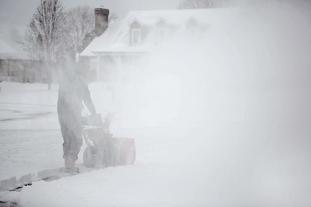
A Blizzard in the Midwest
Across the Upper Midwest and Great Lakes, the storm intensified rapidly into what meteorologists call a “bomb cyclone.”
This occurs when atmospheric pressure drops dramatically in a short period of time, causing a storm to strengthen explosively. The result can be hurricane-force winds, intense snowfall, and whiteout conditions.
Parts of Minnesota, Wisconsin, and Michigan have already been hit with blizzard conditions and snow totals approaching one to two feet, with winds gusting near 70 miles per hour in some areas.
Travel across the region has been severely disrupted. Hundreds of flights were canceled, highways were shut down, and widespread power outages were reported as heavy snow combined with powerful winds.
Tornado Threat Shifts East
While the Midwest battled snow and ice, the southern portion of the storm system began producing severe thunderstorms and tornado warnings.
Meteorologists warn the most dangerous phase may now be shifting toward the Carolinas, Virginia, Maryland, and the Washington, D.C. region.
Weather forecasters have issued unusually high risk levels for severe storms, warning that some areas could experience:
- Damaging winds over 70 mph
- Large hail
- Isolated but potentially strong tornadoes
The combination of warm Gulf moisture and strong atmospheric winds creates the perfect setup for fast-developing supercell thunderstorms.
A Perfect Collision of Weather Systems
So why is this storm so powerful?
Experts say the answer lies in a dramatic dip in the jet stream, which is allowing Arctic air to plunge south while warm, humid air surges north from the Gulf of Mexico.
When these radically different air masses collide, the atmosphere becomes extremely unstable—fuel for explosive storms.
In this case, the clash has created a weather system capable of producing winter blizzards on one side and tornado-producing thunderstorms on the other.
Power Outages, Wildfires, and Travel Chaos
The storm’s reach has been massive.
More than 200,000 people across the Great Lakes region lost power as strong winds downed trees and power lines.
Meanwhile, the same high winds have helped spark and spread wildfires in parts of the Plains, including Nebraska, where emergency crews and National Guard units have been working to contain rapidly moving flames.
Airports across the Midwest also reported hundreds of flight cancellations, creating ripple effects for travelers nationwide.
What Comes Next
Forecasters say the storm system will continue sliding east over the next 24–48 hours, bringing the next wave of severe weather to the Mid-Atlantic and Southeast.
Heavy rain, flooding, and strong storms are expected in many areas, while colder air trailing the system could send temperatures plunging well below average in the days ahead.
For millions of Americans in the storm’s path, the message from weather officials is simple: stay alert.
This unusual storm is a reminder that March can deliver some of the most volatile weather of the year, where winter and spring collide with explosive results.